
Yet another appeal has been against a project on property owned by the Trustees of Reservations on Chappaquiddick. This time, it’s about trails used by oversand vehicles, or OSVs.
On Nov. 6, a citizens’ group consisting of 35 “aggrieved parties, abutters, and residents” appealed to the Massachusetts Department of Environmental Protection, requesting a superseding order of conditions against a 4-1 vote made by the Edgartown conservation commission on Sept. 25, approving a proposed rerouting of existing trails on Chappaquiddick Island.
Appellants cited concerns that the clearing of vegetation during construction of the new paths could lead to worse flooding.
Officials with the Trustees, on the other hand, disagree, and say they are disappointed with the decision to appeal.
“The Trustees is aware of the appeal regarding the Tom’s Neck trail reconfiguration, and is disappointed because it impacts a project bringing conservation, resiliency, and public access benefits to Cape Poge,” Darci Schofield, the Trustees’ director for the Islands, told The Times in an email.
The appeal is the latest in an ongoing dispute over Trustees’ Chappaquiddick properties, between advocates pushing for access and landowners on the small Edgartown island.
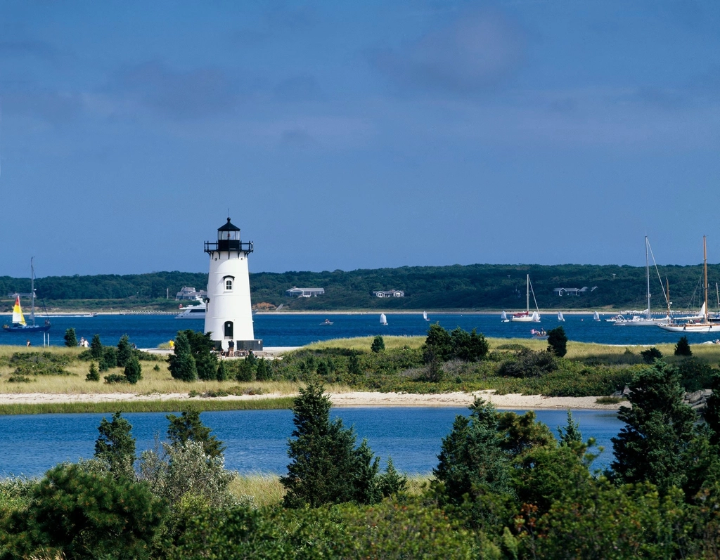
The Trustee’s Tom’s Neck trail is north of the East Beach. It is near where the southeastern portion of Cape Poge Bay meets the mouth of a narrow body of water. The Trustees proposed closing 1,300 feet of the “bayside” OSV trail, and planting this section with American beachgrass, and creating a new pedestrian path.
“This portion in recent years has experienced regular flooding during storms, and astronomical sea level rise,” Schofield said. “As a result of the flooding, salt marsh was beginning to migrate into the trail, which is critical to protect the overall resiliency of Cape Poge.”
Additionally, the Trustees proposed rerouting around 600 feet of the trail to allow OSV access in an area called Tom’s Neck Point, which Schofield called a popular recreation spot. She said the design is consistent with state guidelines for creating OSV trails on barrier beaches. and the “S-design with the topography along the modified trail minimizes the impact to strom flooding.” Still, the project would remove two red cedar trees to accommodate the reconfigured trail, and four trees would need to be replaced.
The Trustees hired the Woods Hole Group, an environmental engineering consultancy, when making the plan. The work was partly funded by a $25,000 grant from the Division of Marine Fisheries awarded last December. At the time, the project was described in a press release from the division as “an example of adaptive management that the Trustees are using to continue their mission of protecting the local environment and promoting access.”
However, the appellants alleged the Trustees failed to provide “a preponderance of credible evidence from a reliable source” that creating a new OSV trail and parking area would not “adversely affect or deteriorate the resource” of “one of the most delicate barrier beach ecosystems in the commonwealth of Massachusetts.”
“We are particularly concerned that cutting in a new trail through the maritime cedar colony will result in flooding to the sole remaining trail,” the appeal reads.
The Chappy landowners appealing further called for state officials to conduct a site visit, and for the project applicants to “do a study and obtain the science for what impact cutting a new trail might have in weakening the barrier, and the potential flow of water and flooding to the sole remaining trail.”
James Williams, representative of the citizens’ group, said not enough time was given for the public to review or comment on the Woods Hole Group’s study, saying questions still remained after the presentation given by the Trustees’ representatives in September.
“I feel there’s a race to make a decision here without due diligence,” he said, saying there seemed to be a lack of knowledge about what was going on in the area.
Williams also said it hasn’t been easy for some residents, whether year-round or seasonal, to follow the details of the Trustees’ proposed projects on Chappaquiddick through the town’s meetings, which he said were not advertised well. Williams has a New Jersey address listed in the appeal.
Williams also pushed back on the “disparaging” NIMBYism accusations some Islanders have made. Williams said although the project wasn’t in his backyard, Chappaquiddick property owners were concerned about how the nearby environment would be impacted, pointing to beach erosion and flooding concerns.
“It’s not a negative aspect,” Williams said. “People want to protect the land around them and promote conservation, which is what the Vineyard is all about.”
Peter Sliwkowski, president of the Martha’s Vineyard Beachgoers Access Group, said while the appeal itself wasn’t surprising, he was taken aback at the resistance to this project. He pointed to the funding from the Division of Marine Fisheries, saying this showed state environmental officials thought there was merit to the Trustees’ proposal. Sliwkowski also underscored that the OSV trails were “fundamental access” points for older individuals and children trying to visit the beach.
“It’s just sort of disappointing … just frustrating,” he said.
The citizen’s group also argued in the appeal the commission should not have made the approval when the “location of the project locus” is under review by the state’s Department of Environmental Protection and the Massachusetts Environmental Policy Act Office.
The Chappaquiddick properties that are undergoing state review are Leland Beach and the Cape Poge Wildlife Refuge, areas popular with recreational fishermen and beachgoers. The Trustees and protesting abutters appealed the conditions the commission had placed on the properties, which limited the number of oversand vehicles to 200 at Leland and 30 at Cape Poge, in May. However, each party appealed under differing reasons. The Trustees claimed the commission’s decision was overreach, while the abutters argued the Trustees failed to provide sufficient information about how oversand vehicles would impact the environment and wildlife at the beaches.
“That’s the 100,000-pound gorilla,” Sliwkowski said.
These areas had been the epicenter of a fierce disagreement between a group of Cape Poge property owners and public beach access advocates.
Mary Dettloff, the Trustees’ director of public relations, said Friday is the deadline for the state to make a decision, although it won’t be made public until the following week.
Open it all up, after all, it belongs to the people not just the people who live on Chappy. MAGA.
There is nothing quite as beautiful as beach rigs on the beach.
The Massachusetts Division of Marine Fisheries highlighted this plan as an example of adaptive management. The Edgartown Conservation Committee overwhelmingly approved the plan. But a tiny group of self-serving non-resident abutters, in a blatant effort to enshrine a private sanctuary, know better? Wow. The only inaccuracy in this article is the charge of NIMBYism being assigned to this select group of obstructionists. Given this public access has peacefully existed for 80 years, they are technically RDOAIMBY – Remove Decades Of Access In My Back Yard.
This project aims to restore public OSV access to the bayside, providing essential entry points to calmer waters. Without this OSV access, families with young children, elderly visitors, and individuals with disabilities would face significant obstacles in reaching the area.
The plan was developed by The Trustees in partnership with the Woods Hole Group, a highly respected environmental consulting and engineering firm based in Massachusetts. With over 35 years of expertise and a proven track record of completing more than 3,000 projects worldwide, the Woods Hole Group specializes in science-based solutions for coastal, ocean, wetland, and terrestrial challenges.
Further bolstering the project, it received taxpayer funding through a grant from the Division of Marine Fisheries (DMF), emphasizing its importance to the Commonweath.
Lastly, while Mr. Williams disputes the “disparaging” NIMBYism accusations made by some Islanders, it’s worth noting that more than half of the participants identifying as residents on the appeal either own waterfront property and/or have access to private beaches. Unlike the prior appeals, I agree with him, the dynamics of this particular appeal seems less about “NIMBYism” and more reflective of an “elitist” perspective.
My heart hurts at the ongoing fight against environmentally responsible access to Trustees owned properties. My 4 children have grown up on that beautiful bit of sand at the mouth of Cape Poge Bay. It is where we gather with friends and family and where countless memories have been made. Our time together on this amazing planet is precious. The self centered, seemingly endless fight to prevent responsible access by those who love and care for our island but cannot afford waterfront homes is heartbreaking and head scratching. Surely with dialog instead of lawyers we can find a better way. Why don’t we come together to plant and nurture 20 cedars to replace the 2 lost (or such)? I am so grateful for the work of MVBAG and others to protect our beautiful beaches AND enable access consistent with historical use and the TTOR mission.
Kathy, thank you for a heartfelt response.
You have the right idea: let’s work together to preserve what we love for our loved ones.
“Our time together on this amazing planet is precious.”
Why should there be motor vehicle access to our beaches?
When did they become the norm?
Albert, I believe it was 1948 on this particular stretch of beach
Seems like the Commonwealth is reaching the same conclusion as almost all Vineyard citizens.
We must be adaptive to the evolving reality of nature, but we must also respect property law. Mother Nature may take what she wants, but the same does not apply to egregiously entitled abbuters. Let us now heal and move forward as neighbors.
The state has just determined the project does not require the preparation of an Environmental Impact Report (EIR). It includes the public submissions of interest and makes for some interesting reading. You can find the document here:
https://eeaonline.eea.state.ma.us/EEA/MEPA-eMonitor/submittal/34bdb063-3c00-44a9-947c-f7470f2ccfca
Fun Facts:
1. There is not a single public way beyond the dyke bridge.
2. All of the land north of the dyke bridge, save one parcel owned by the Town, is privately owned.
3. Two of these “elitist” families (who are still there and among the people appealing) gifted parcels of land on this fragile resource to TTOR on the condition that they “are to be held by [TTOR] for the benefit, education, and enjoyment of the public (but only to the extent that any use by the public is consistent with the preservation of the natural resources of the Granted Premises) . . . .” This is not my opinion, rather it is the express language in the deed granting a portion of the beach to TTOR. Either these elitists have really dumb lawyers, or they have a sincere desire to ensure public access that is consistent with preservation.
4. Contrary to popular belief, the mere use of phrases like “historic use” and “historic access” do not create an independent legal right to use the land of another. As such, OSV use on CP has always been with the permission of the private landowners. That’s right. They have allowed you to enjoy it for 80 years (super nice of them, in my opinion).
Which is more likely, that these families now suddenly hate the public, or, that they are simply staying true to their demonstrated commitment to preservation?