


Following the recent release of a draft management plan for Trustees of Reservations beaches that has received sharp criticism, the Trustees’ president and its top official on the Vineyard both met with The Times to discuss over-sand vehicle (OSV) and dog restrictions.
Standing at the over-sand trail entrance to Norton Point, John Judge, the president of the Trustees, and Darci Schofield, superintendent of the Trustees’ Island properties, said the Trustees itself and the proposed regulations are all about striking a balance between recreation and conservation.
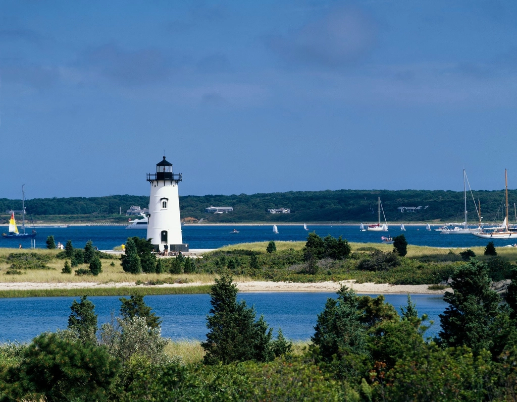
With a newly restored sand dune behind him, Judge said, “We can succeed at the intersection of recreation and resiliency.”
One of the ways to achieve resiliency, he said, is by preventing degradation of dunes and other natural features that protect the shoreline through OSV “middle road” management practices.
“We’re keeping 75 percent of the OSV trails open, so 130 miles of OSV trails, which I think is a pretty good compromise.”
Judge said he’s not only concerned about loss of habitat but loss of beach, the two of which are interconnected. “You know we’ve lost 93 acres from 1994 to 2017,” he said of beaches.
OSV can rut the sand and erode dunes, Judge said. He pointed to a tilted fence stake nearby with a tire mark leading up to it.
Schofield said understandable vehicular errors like that can amount to “a death of a thousand cuts” without proper oversight.
“When it comes to dirt roads, sand roads, camp roads, obviously operator error affects habitat loss,” Judge said. “You know, people backing in, going where they’re not supposed to. But then just the constant use, the beating down of roads …” Judge went on to say these degradations can exacerbate rainstorms and other weather damage: “So the less adaptive and the less resilient roads are, the more they are going to be washed away.”
Again pointing to the tilted stake and tire mark, behind which was new beachgrass planted as part of the dune restoration, Schofield said preservation of flora is key to keeping the shoreline intact.
“Dune restoration near us,” Schofield said, “wouldn’t be sustained without vegetation. This dune grass is a critical component of resilience for a variety of reasons. So having these OSV trails, it’s really important, in addition to following the guidelines around that, to ensure they’re not intersecting or eroding this critical vegetation, which is a key to our long-term resilience of these beaches.”
For Norton Point in particular, the OSV cap is “about 120,” which is established in part when the vehicle queue stretches back to the gate at Katama Road. For bird safety, all OSV are escorted in, she said.
“Folks are driving 5 miles per hour. Rangers are on the ground literally walking the vehicles across the dune to make sure there’s no OSV interference with the chicks. It’s very staff-intensive. It’s just in Norton Point … We utilize this mechanism, through the habitat conservation plan, that was designed to really address these kinds of pinch points.”
Other than the rangers, Schofield said no pedestrians are allowed on the Noton Point OSV trail when OSV are allowed on.
As to dogs, Judge said most folks are responsible with their pets, but there are those who just don’t clean up after them. Judge said he understands people’s frustration with dog restrictions.
“As a dog owner, I understand where folks are coming from,” he said. “I love dogs, but it really does come down to 37 percent loss of birds in North America, and 93-acre loss here.”
Schofield punctuated the potential for failing to clean up after a dog by noting she saw dog excrement at the entrance to the beach.
“[W]e can really empathize,” she said. “Our dogs are part of our families. Families want dogs to be part of our beach experience.”
She went on to say, “I definitely empathize, and I feel that struggle because I can’t bring my dog to the beach. I live in Chilmark. Lucy Vincent does not let dogs on the beach right now.”
Schofield stressed the Trustees want public input on balancing use, preservation, and access.
“We understand we have not thought of everything,” she said. “We’ve put forth our very best effort grounded in science, data, expertise, and regulations for this draft management plan. But we know we didn’t think of everything, so what are your thoughts? How can we align all of these uses together? I encourage the public to present those ideas to us.”
“I think that’s the opportunity — to tap into the collective intelligence of the community,” Judge said.
The public’s opportunities to comment on the draft management plan are coming in August. An initial forum will be held at the Chappy Community Center on August 8 from 5 pm to 6:30 pm. A second forum will take place at the Edgartown library, August 10, from 10 am to 11:30 am. And a final forum will take place on August 16, via Zoom, from 5 pm to 6:30 pm.
This damage control interview wouldn’t have been necessary if these two had sought the “collective intelligence of the community” prior to publishing their manifesto. The article doesn’t go into detail about their professional backgrounds and why we should trust them in the positions they have. The hand grenade they lobbed caused a lot of collateral damage. Smiling in a photo op picture at Norton Point doesn’t change anything.
1. I do not have the expertise to say they are right or wrong but their comments above saying OSVs are damaging the dunes is a direct contradiction to what their own organization spokesperson and beach manager told our packed house annual meeting of the Katama Assn. apx three short years ago. And people have been driving on Norton Point (and other MV beaches prior) for decades. So now vehicles and not weather are the problem?
2. Because the wildlife scientists data shows that the piping plover mating pairs have increased significantly over the past 20 years and also that the same data shows that the overwhelming death or destruction of plovers and/or their eggs and hatchlings is not due to humans I believe it is time and appropriate for the TTR to share the “end game” plan for making Norton Point and Chappy less restrictive to OSVs in subsequent summer seasons.
OSVs do not kill Piping Plovers.
Fisherman who walk in do…
Albert — I will not categorize your comment, but suffice it to say only a complete jackasses would deliberately crush eggs for fun. And anyone walking in who crushed any eggs by accident shouldn’t be out of the institution without a caregiver..
I am sure the drivers of the osv’s have no idea if they are running over a plover, and would use every tactic possible to not run them over.
Unless they were complete jackasses of course.
Well said
Exactly! It would go against are mutual interests. We who want the beaches open want them to procreate as fast as possible to get them off the protected list while others just want to protect them and the land. Both don’t have to be mutually exclusive.
Don, I have done enough whining on this subject and too tired to go on. On to the next!
Take a moment and call the tour line or office line for Cape Pogue
They do not answer the phone and have not for the last 3 months.
Why are these two in a position of power when they can’t even get the phones answered or even purchase an answering machine!
From their website:
Telephone: 508.627.7689
Tours: 508.627.3599
The land owners put these people in a position power.
Don, the category is sarcasm.
I catch all my fish in white paper, boneless, skinless.
I have enjoyed hundereds miles of joy riding on Trustee beaches.
More than likely I have at least one dead plover notch on my belt, the chicks are so little.
Real fishermen walk in.
Island fishermen prefer to enjoy their natural beauty air-conditioned.
Al and some on Chappy like to take their limousine to the fishing hole to watch those brave anglers wrestle the beast to shore knowing that they could never get their hands dirty with such menial tasks. And if you so freely admit to knowing nothing about fishing then why opine?lastly, I wouldn’t be too proud that you have “a chick under your belt” sounds like that’s the attitude that the trustees are looking to stop. So thanks for making it harder for the rest of us looking to enjoy ALL the trustee land.
Carl, I was the Captain of a sport fishing boat for four years.
That background gives me no right to drive my pickup truck on privately owned property.
The chick belt notch line came from the same guy who told me they taste just like chicken.
He had huge beach rig.
He slept in it.
You can enjoy all of the Trustee land by taking it by emminit domain.
At fair market prices.
Your tax dollars at work.
Do you think the Town of Edgartown would do a better job of management of beach property than the Trustees?
The County?
The State?
Biden/Trump?
Albert, no I don’t think any of those entireties can manage it better than the trustees but that bar is set very very low. Don’t know why it’s not sinking in but the trustees do manage public land. And they take our tax dollars. I’m not sure what to believe when it comes to your comments about your experience with fishing as your previous posts contradict your most recent, therefore I think you are just trying to bait people, pun intended and no longer worth replies.
Excellent appraisal.
John Judge a strong leader for the Trustees. Nice work.
Every God fearing American Patroit has the God given Right to tear up beaches with big scary trucks.
So many assumptions on their part, with no research or experiential foundation. Feces from the dogs of idiots who do not clean up after them…. how big a problem compared to feces from seals, otters, deer, raccoons, etc.? Or is that just a stalking horse for getting rid of dogs?
“You know we’ve lost 93 acres from 1994 to 2017,” he said of beaches. OSV can rut the sand and erode dunes,” Judge said.
Is any of the of beach erosion is due to vehicle tracks or is it is due to the natural erosion of a terminal moraine? Look at the huge loss of Wasque land 10 years ago years ago. That was storms and water currents attacking the face of the beach, not from vehicle sand tracks inland. Their distain for the idea that they should have consulted with those with real experience on the ground is telling, as is the smiling photo op.
And there it is. They finally said it out loud. Then STOP TAKING PEOPLES MONEY for OSV permits only to laugh behind their backs because you duped them. Bernie Madoff had better scruples. This group just doesn’t like OSV but certainly likes their money.
I think the following excerpt from Chris Kennedy’s Letter to John Judge says it all. Darci and John have very experience in the historical use of the properties and overall value to the culture of the Vineyard.
“However, perhaps some of the most discouraging parts of this plan is its ignorance of historical use of trails for recreation, shellfishing, fin fishing and quiet rejuvenation in nature. The world envisioned in this draft beach management plan is not the kind of place which Charles Eliot ever envisioned. Even with sea level rise we can find the balance between public use and enjoyment and protecting the places that we love. That spirit is missing in this plan.
… in my opinion, you should withdraw the plan and re-draft it with input from beach managers, our beach partner-owners as well as the local community BEFORE you present a completed draft plan. There is no “fixing” this draft plan. It needs a complete re-write with a balanced point of view which provides more than lip service to our mission and truly embraces our mission of public use and enjoyment as well as protection of the properties which we all love and seek to protect. “
Thank you Peter.
Like you, those of us who not only have spent thousands of dollars on OSV permits and just as many (if not more) hours enjoying the properties and respecting the rules over the decades were blindsided by this draft proposal. The fact it was posted without any prior notice or discussion or discussion beforehand with the various stakeholders shows just how out out touch the Trustees have become with the people that actually allow them to exist in the first place.
I implore any and everyone that holds these properties in high regard to show up and speak out about any and all concerns regarding the draft plan at the posted meeting times. I plan to be there and hope to see you all there as well.
It is nice to comment online it will be more important to show up at these meetings and voice our concerns. When are people who pay for these beaches and Management going to be important. Why are the people treated like a second class citizens. If they closed off the far section of Norton point to vehicle traffic birds would find their way there and they can have that section and we get the rest.
Bob, “we” don’t own any of it.
The Trustees do.
Are you a member?
“We” do own it. Norton Point Beach (all the way through to Leland’s Beach) is owned by Dukes County, not the TTOTR (TTOR are under contract to manage it and get a % of the permit fees). Leland’s Beach to Dyke Bridge is owned by the State of Massachusetts (MassWildlife) and bought explicitly for angler access. TTOTR are under agreement to manage Leeland’s as well. North of Dyke Bridge has mixed ownership, including TTOTR, the town of Edgartown, and the Federal Government (Poge Light) and a small set of private citizens. Join the Facebook MV Beachgoer’s Access Group (MVBAG) for more FACTS on our beaches and to promote beach access for all interests. Thanks.
Albert the trustees take grant money from the government. AKA tax money. Check their webpage. And when you take taxpayer money you can not discriminate from who can benefit from those tax dollars. Also it was recently mentioned that the trustees also manage some public land.
Carl, where in the grant does it say that the Trustees must provide public vehicular access to its private property?
Grants, or not, you cannot discriminate on who uses your property but you certainly can discriminate on how it is used.
The grants are peanuts compared to the Trustees operating budget.
If the State thinks it not getting the value for tax dollar it can always shut down the grants, it will hardly missed.
When you rent a beach house you will most likely be prohibited from driving on the beach, but not from fishing.
Ownership has rights.
You have no rights to private property.
You are a guest
If you want to beach fish buy a beach.
There is no shortage of beach available, at a price.
Why are they selling passes for vehicular access to the beach? We do own it. They took the tax money, it’s too late.
FACT CHECK:
John Judge said ” “We’re keeping 75 percent of the OSV trails open, so 130 miles of OSV trails, which I think is a pretty good compromise.”
Using Google Earth Pro, I measured every available trail that we had access to in September 2021 (max access). I came up with 19.96 and based on the draft Beach Management Plan, the trails would be reduced to 10.67. A reduction of 46.54%. (see note)
A simple fact check is that outer beach measure from the OSV Access point at Left Fork to the Gut is approximately 11 miles. It would require a 11 lane highway of trails from Left Fork all the way to Gut to get close to 130 miles.
(Note: I did not include OSV Access Corridor from Norton Point to Wasque since the current beach topology does not support it but it is in the plan as available to public)
Here is Google Earth Pro .kmz file if anyone want to validate my analysis –
https://drive.google.com/file/d/1-QxLzQsSiBexiUZbFTY6n_-E1EU-HprJ/view?usp=sharing
FACT CHECK: John Judge said “As a dog owner, I understand where folks are coming from,” he said. “I love dogs, but it really does come down to 37 percent loss of birds in North America, and 93-acre loss here.”
From an article by the American Bird Conservancy “3 BILLION BIRDS GONE Help Reverse Bird Declines Today!” – https://tinyurl.com/nhhstswc
“Aside from habitat loss and degradation, other major human-caused threats to birds come from cats and other invasive species; collisions with glass and industrial infrastructure such as communications towers and wind turbines; and exposure to pesticides and other toxics.”
Interesting that there is no mention of dogs as a primary threat to bird.
What is most interesting is that Trustees purposely reduce the overall bird population through their predator management program to protect the Piping Plover specifically targeting Crows, Great Horned Owls, and Ravens. In addition, the TTOR use of toxic eggs throughout the years may indiscriminately affect other bird species.
Directly, from the Certificate of Inclusion, approved June 4 2020 as part of the state’s Habitat Conservation Plan https://tinyurl.com/whxf6x8w
Link to Mitigation Plan Section: https://tinyurl.com/mudj5yw8
In order to mitigate for piping plover pairs that may be impacted under the HCP, The Trustees will implement a comprehensive predator management plan at Crane Beach, Ipswich, Massachusetts, through contracting with US Department of Agriculture-Wildlife Services (USDA-WS). The same body of work will be used to mitigate for take exposures on Nantucket (one brood). USDA-WS has identified four species of predators impacting the reproductive success of nesting shorebirds at Crane Beach: American crow, common raven, great-horned owl, and Eastern coyote. Each species has been responsible for shorebird predation at various times of the year and requires different management practices. In 2020, we will use mock piping plover exclosures baited with hard-boiled chicken eggs to detect avian nest predators. Additionally, The Trustees conducts a similar predator program on Martha’s Vineyard, and efforts will continue for 2020. These are not considered comprehensive and so do not contribute towards our HCP mitigation efforts, but they do contribute towards successful management of nesting shorebirds…..
On Martha’s Vineyard, American crows and striped skunk are the main predators. The USDA-WS will conduct crow control using methods similar to those used on Crane Beach on Leland, East, and Norton Point Beach. Trustees staff will place box traps and monitor them daily for striped skunk. Captured animals will be euthanized using CO2 in a chamber. USDA-WS will conduct box trapping when they are on site. The Trustees will monitor and provide an annual report to MADFW. This report will contain the number of plover broods exposed to covered activities, number of breeding pairs of piping plovers and least terns benefitting from the comprehensive predator management, program reach and effectiveness (e.g. number of warnings, citations, any violations, changes in public attitude), documentation that the selective predator management was implemented (i.e. paid invoices and contractor final report), piping plover and least tern productivity for the site, causes of nest and/or chick loss, and any mitigation credits or deficits that will be carried over into the following season. Itemization of Costs for Predator Management (Estimated): Item Cost Contract Services (USDA-WS)/per year $8500\
FACT CHECK: Judge said “he’s not only concerned about loss of habitat but loss of beach, the two of which are interconnected. “You know we’ve lost 93 acres from 1994 to 2017,” he said of beaches. OSV can rut the sand and erode dunes, Judge said. He pointed to a tilted fence stake nearby with a tire mark leading up to it.”
John is implying that OSV was a major cause of the lost 93 acres. The vast majority of this beach loss occurred at Wasque Point. It was caused by the breach in the Wasque area in 2007. Because of the more intense winter nor’easters and the breach an immense amount of land drifted off into the ocean. The Schifters moved their house because of it. A vast majority of the bluff erosion there occurs in the winter when there are no trucks around.
The south facing barrier beach of the Vineyard is by definition a dynamic landform. It has been a state of constant change throughout its history. As an example, here is a link to an ELDRIDGE’S MAP OF MARTHA’S VINEYARD of 1892 showing a breach on the South Side. Historically, a breach occurs about every 35-50 years.
https://tinyurl.com/yckjrwak
What are the Trustees doing for Island fishermen who can not afford a beach rig?
Is beach fishing just for rich people?
Should the Trustees provide very low cost rentals?
Al, you said it before you have no interest in fishing. But you should know that OB recently built a terrific fishing pier.